Revisiting Brasília
Thursday, 6th September 2012 by Kyle Kusch
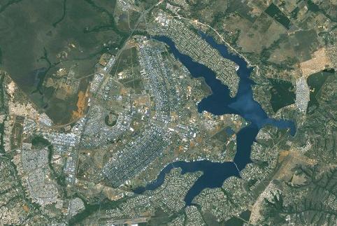
Back in February 2011, Google Sightseeing visited the city of Brasília, the metropolis built in 1960 to serve as the new capital of Brazil. Designed by Oscar Niemeyer and recognised as one of the greatest civic engineering achievements in history, the city core’s unique aeroplane-shaped design (the ‘Pilot Plan’) has been enshrined as an UNESCO World Heritage Site. With last month’s release of brand-new Street View and 45° imagery throughout much of Brazil, we finally get a chance to look at Niemeyer’s stunning designs up close.

The core government and cultural buildings of Brasília lie along the great street known as the Monumental Axis. The centrepiece of the Axis is the National Congress, the most well-known example of Niemeyer’s ultra-Modernist architecture based around abstract shapes cast in concrete. The Senate chambers sit on the left and the Chamber of Deputies sits on the right, separated by two tall office towers.

Perhaps the most striking buildings in Brasília are the National Museum and the Metropolitan Cathedral. The National Museum is contained in a spheroid concrete dome, while the Cathedral across the street is a striking white hyperboloid structure.


Between the Congress building and the National Cathedral lies the Mall of Ministries, two sets of monolithic skyscrapers (one for each side of the Axis) that house the various government ministries.

At the very end of the Monumental Axis is the giant plaza that sits in front of the Supreme Court building. Standing at the entrance to the plaza is this giant plaque that details the timeline of events that led to the creation of the capital city.

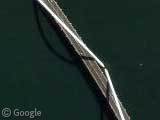
Along with the Pilot Plan, the other dominant feature of Brasília is Lake Paranóa, an artificial lake created as both a reservoir and as a playground. The lake is surrounded by upper-class housing developments. The main crossing from Brasília to its suburbs across the lake is the Juscelino Kubitschek Bridge. Built in 2002, the 1,200 m (3,900 ft) bridge is supported by three 61 m (200 ft) high asymmetrical steel arches that crisscross the bridge diagonally.

Brasília looks just as stunning in the new 45° imagery that covers the Pilot Plan. For example, viewers now get a true feel for the size of the massive television tower that lies in the middle of the Axis.

The 45° imagery also captures the reconstruction of Estádio Mané Garrincha, which is in the process of being rebuilt as the National Stadium of Brasília. When rebuilt, the stadium will seat 71,500 spectators and play host to seven matches during the 2014 FIFA World Cup.

Niemeyer’s original plan was to house 500,000 people along the curved ‘wings’ of the Pilot Plan in giant superblocks.

Each superblock is designated for residential, commercial, or institutional use relative to the block’s position along the axis. Blocks closest to the Monumental Axis host high-end commercial and institutional developments (as well as plenty of traffic, owing to the city being designed for the automobile). Residential blocks consist of large, imposing apartment complexes. Each residential superblock is bounded by a local commercial street.


Sadly, most residents of Brasília do not get to enjoy the relative opulence of life in the Pilot Plan or on Lake Paranóa. The Pilot Plan was only designed for 500,000 residents, but today Brasília has a metropolitan population over seven times that size, most of whom cannot afford to live in the city centre. Most residents of the Federal District instead live in the suburbs, which range from middle-class and comfortable to unplanned and overcrowded. Street View also ventured into of the poorer areas where, sadly, scenes of poverty are all too common. In outlying neighbourhoods of suburbs such as Sobradinho, slums hang over the cliffside high above Brasilia.


For more about Brasília, visit its Wikipedia article.
About the author
Kyle is a jack-of-all-trades geographer and archivist in rural British Columbia and was formerly the proprietor of humble geography blog The Basement Geographer. He enjoys a good game of hockey and a good 30-km walk with a frozen beverage in hand.
And then they go and break all the windows in their lovely shiny buildings …
Juscelino Kubitschek Bridge is the coolest bridge ever.
I agree Frimmy – it’s bloody brilliant!
Many other interesting points of Brasilia in Google Earth can be found on site http://www.pontosbr.com.