Undiscovered Hawaii: Lanai, Kahoolawe, and Niihau
Friday, 22nd May 2015 by Kyle Kusch
Hawaii is one of the world’s great tourist destinations, with millions of people from around the world streaming into the islands each year. While most tourists lounge their time away on the beaches of Maui, Oahu, Molokai, Kauai, and the Big Island of Hawaii, many forget that there are eight major islands in the archipelago. Today we're going to take a look at the other three major islands of the 50th state of the United States.
We begin with Lanai (Lāna’i), known as the ‘Pineapple Isle’. Measuring 364 km2 (141 sq. mi.), Lanai is the smallest publicly accessible island of Hawaii. It sits just 14 km (9 mi) west of Maui and south of Molokai but was only inhabited in the 1500s, hundreds of years after its neighbours, for fear that the island was haunted by evil spirits.
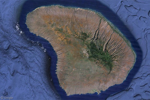
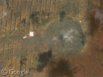
Lanai is home to the largest prehistoric village ruins in Hawaii, Kaunolu. Once the favourite fishing spot of King Kamehameha I, the village was abandoned in the 1880s. Here, the faint black outlines of the building foundations and archaeological plots can be seen.
Dole Foods purchased 98 percent of Lanai in 1922 and turned it into the world’s largest pineapple plantation, as the fertile volcanic soil of the island was perfect for the crop. When the pineapple industry began to bottom out in the 1980s, Dole’s then-parent, Castle & Cooke, began closing down the plantations and refocusing the island’s economy around tourism. Today, the major employers are the two major golf resort complexes built within the past 25 years. Still, the outlines of the pineapple and sugarcane plots are readily visible from the air. In June 2012, Castle & Cooke sold their 98 percent to Oracle multi-billionaire Larry Ellison for an estimated US$600 million; the other two percent is owned by the state.
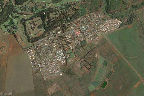
The only settlement on the island is Lanai City, population 3,100. Lanai City was built by Dole in 1923 to house plantation workers and represents the only completely intact company town in Hawaii. The historic town centre is focused around what else but Dole Park, and was all decked out for Christmas celebrations when Google Street View came by in November 2011.


While there are hundreds of kilometres of roads on Lanai, 90 percent of them are four-wheel-drive-only. One of the few paved roads outside Lanai City is the Keomuku Highway, which twists its way through the red volcanic soil down to the ocean on the north side of Lanai, providing stunning views of Molokai and Maui in the distance.

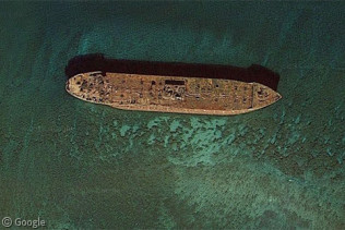
Lanai is also known for its beaches. Its most famous beach is Kaiolohia at the north end of the Keomuku Highway, where this World War II-era cargo ship has sat marooned for decades. Just remember, when you’re heading to Kaiolohia, there is absolutely no nude sunbathing.

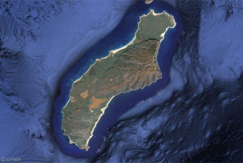
Located 29 km (18 mi) southeast of Lanai and 11 km (7 mi) west of Maui is Kahoolawe (Kahoʻolawe). About one-third the size of Lanai, Kahoolawe is the smallest and most arid of the eight main Hawaiian Islands. When the first Hawaiian settlers arrived a millennium ago the island had a dry forest landscape, but this became a more savanna-like environment as the early settlers stripped the land for firewood and agricultural purposes. Always sparsely populated because of its aridity and lack of freshwater, the island has been completely uninhabited for over 70 years.
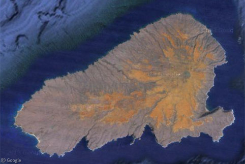
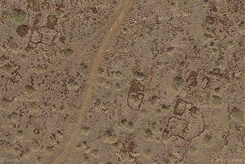
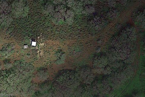
In the mid-19th century, Kahoolawe served as a penal colony before being turned over to ranching interests in 1858. Drought and overgrazing led to much of the topsoil blowing away, and the last ranch was abandoned in 1941. The island’s nickname is the ‘Target Isle’ due to its use by the US Armed Forces as a bombing range between 1941 and 1990. Old bombing facilities are still present across Kahoolawe. Today, the entire island is a state-owned cultural and natural preserve. Reforestation efforts have included blowing up sections of the hardpan soil with lines of explosives and planting seedlings in the resulting troughs.
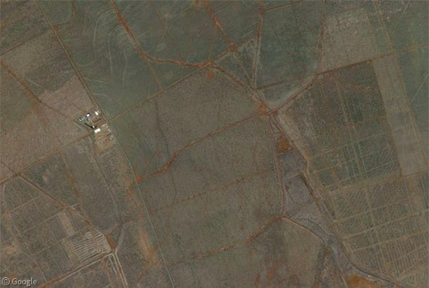
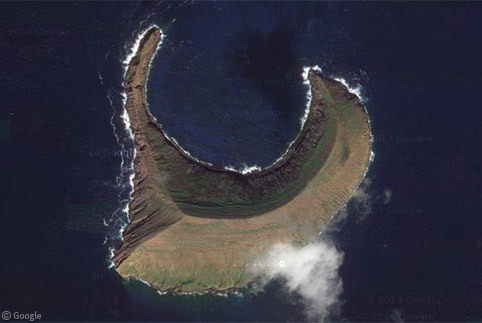
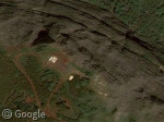
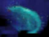
The biggest reminder of Kahoolawe’s military history is the massive Sailor Hat crater on the south coast. In 1965, the US Navy detonated 500 tons of TNT here; a blast so powerful it cracked open the volcanic island’s caprock and penetrated the water table. The crater then filled with ocean water, and the resulting pond has been colonised by a unique species of subterranean shrimp. Sadly the crater is obscured by cloud in Google's current satellite imagery, but can be seen below in an image captured in 2012.

Niihau (Niʻihau) is the westernmost of the eight major islands, 28 km (15 mi) west of Kauai. It has the unique distinction of being completely privately owned. Purchased from the Kingdom of Hawaii by Francis and Elizabeth Sinclair for US$10,000 in 1863, the island remains in the family’s hands today. Wishing to preserve the cultural traditions of the Hawaiian residents, the owners began restricting access to Niihau in 1915, hence its nickname, the ‘Forbidden Isle’. The crescent-shaped island just to the north of Niihau is Lehua, a volcanic tuff cone which is part of the extinct Niihau volcano which originally formed 4.9 million years ago.
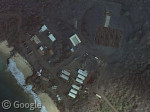
The residents of Niihau live in the village of Pu’uwai. Pu’uwai has around 130 residents, almost all Native Hawaiians who practice subsistence farming, make shell jewellery for income, and live a largely technology-free lifestyle. There are no cars, shops, or telephones. All houses and the lone school (in which students speak only Hawaiian until middle school), operate on solar power. The major source of income on the island is a small Navy installation high atop the island’s cliffs used in conjunction with a missile range on Kauai.
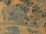
In an attempt to control the feral sheep and pig population, Niihau been opened to limited safari tourism in recent years as well as half-day sightseeing tours. Visitors are kept well away from Pu’uwai and are not allowed to stay overnight. Small shelters provide the closest thing to a modern convenience for these tourists.
For more information on the individual Hawaiian Islands, Wikipedia is a handy place to start.
About the author
Kyle is a jack-of-all-trades geographer and archivist in rural British Columbia and was formerly the proprietor of humble geography blog The Basement Geographer. He enjoys a good game of hockey and a good 30-km walk with a frozen beverage in hand.
There has not been a new Google Sightseeing post since this one on May 22, 2015. Can we expect more posts, or is the this end of the road? I would be sad to see the site stop updating.