Mississippi Basin Model
Monday, 26th November 2007 by James Turnbull
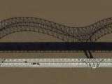
The Mississippi Basin Model reproduces the drainage basin of the Mississippi River at a horizontal scale of 1:2000 and a vertical scale of 1:100. This makes it the largest small-scale working model in the world1!
The concrete model was built by the Army Corps of Engineers in the 1940s, and initial earthwork was carried out by German POWs. It was eventually completed in 1966.
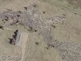
By the 1980s the model was superseded by computer modelling techniques, but it was widely agreed that the model had been a success: helping to solve numerous flood-control problems and thus saving lives.
Thanks to Ned Mitchell.
-
Which is total nonsense, how can anything ever be the largest-small thing? ↩︎
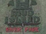
Great picture. This is a neat model of the Mississippi River. But it is located at Memphis Tennessee on Mud Island between Tennessee and Arkansas. The state of Mississippi is quite a few miles South of this location.
Grins Herb
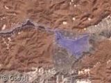
Interestingly enough, the US Army Corps of Engineers’ San Francisco Bay model (http://www.spn.usace.army.mil/bmvc/ or View Placemark) is at a horizontal scale of 1:1000. Does that make it a larger small-scale working model? The Mississippi basin model is probably physically bigger, but not as much detail.
@Herb: That’s weird, it seems to be linking the right place now? However, you make a good point: Mud island‘s model is also worth a look.
@Wayne: I think that, despite being a larger scale, it’s a model of a physically smaller original, so the model is smaller. Or something. Who knows!
So what, then, is up with the miniature race track and airfield just to the east?
…To evacuate the miniature people in case of a flood?! 🙂
pat 🙂
Hmm, and does that “Sewage Lagoon” to the north-west simulate the ecological state of the gulf? 😉
Some photos here, the second one really shows the detail.
Thanks, James, for the post. I figured the submittal was long-forgotten.
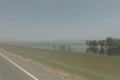
The model was “donated” to the City of Jackson back in the 1980s by the Corps of Engineers, as it was deemed too expensive to maintain. The city apparently agrees, as the model now sits abandoned and overgrown. Quite sad.
The racetrack and airfield are part of a city park that has been put in around the model…for go-carts and remote-controlled airplanes. Seems the theme of miniaturization has survived the decades!
Hi,
I explored the area in March 2009 and took some photos. The area is in a sad state, have a look.
http://cid-573f731c727b2b01.skydrive.live.com/self.aspx/Camp%20Clinton%20Remnants/