Easter Island (Island Week 2)
Thursday, 30th August 2007 by Alex Turnbull
(It’s Island Week 2 here at GSS, which means we’ll mostly be posting about Islands. For about a week.)
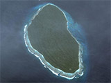
Located in the south eastern Pacific Ocean, almost four thousand kilometers from continental Chile, Easter Island - or locally Rapa Nui - is one of the world's most isolated inhabited islands1, as well as one of the world’s most fascinating archaeological sites.
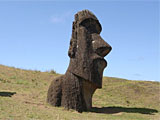 Photo of Rano Raraku Moai from mappic.org
The human history of Easter Island probably began somewhere between AD 300 and 1200 when people from the islands west of here landed with the tools, animals and provisions to stay for good. Although only 171 km2 in area, at the time Easter Island had extensive forests, and the volcanic craters held drinking water - which is an important feature on an island with no rivers.
Somewhere between AD 1000 and 1500, the Rapanui began a period of frantic construction of enormous stone statues - the Moai, for which Easter Island is world famous today. These enigmatic figures represented the islander's deified ancestors, and were mostly placed near the coast, with their backs to the sea.
 Moai of Ahu Nau Nau, Anakena Beach (Picture)
Moai are hewn from the island's volcanic rock2, and the largest Moai erected was almost 10 metres high and weighed 75 tonnes; their production and transportation is considered a remarkable accomplishment.
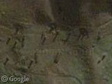
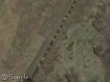 Moai of Ahu Tongariki, (Picture)
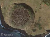
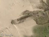
887 Moai have been identified to date, however only a quarter ever made it to one of the coastal Ahu platforms - nearly half of all Moai remain at a single site called Rano Raraku, the volcanic crater where 95% were originally carved. The landscape is littered with 397 Moai - some half-finished, some semi-submerged in the earth through erosion, and others never even detached from the rock.3
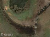
 Rano Raraku crater, Rano Raraku Moai (Picture)
By the time explorers arrived here in the 18th Century, the forests of the island had completely disappeared. It's unknown whether or not the Rapanui had used all the trees in the construction of the Moai, or if some other ecological factor was involved, but either way the islanders were now trapped - there was no longer any wood available for making seaworthy canoes.
After this things began to go rapidly downhill for the inhabitants of Easter Island. There followed a period of tribal wars, raids by Peruvian slavers, epidemics of European diseases, and the conversion of the entire island into a sheep farm. During this period much Rapa Nui culture was lost forever, nearly all of the Moai were deliberately toppled (probably by warring tribal factions), and by the late 19th century only 111 of the indigenous people remained alive.
Somehow, against all the odds, today there are several thousand descendants of the surviving 111 Rapanui living on Easter Island - which now has sustainable forestry and the longest runway in Polynesia (having been extended to function as an emergency landing place for the U.S. Space Shuttle). The Moai have returned too - many have been re-erected on their Ahus around the island and one has even been given new eyes.
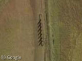 Moai at Ahu Akivi, unusual in not being on the coast, and facing towards the sea (Picture)
Read more about Easter Island and Moai at Wikipedia.
Thanks to Josh, Adam, Reinhold and Didier.
-
Featured earlier in the week, Easter Island's nearest inhabited neighbour is Pitcairn Island - 1,931 kilometers west of here. ↩︎
-
Whilst most Moai were carved from easily worked tuff, Hoa Hakananai'a is one of just ten Moai that were carved from much harder basalt. ↩︎
-
The biggest Moai ever carved also remains on the slopes of Rano Raraku, which at 21.6 metres tall and around 270 tonnes was probably impossible for the Rapanui to move. ↩︎
About the author
Alex has decided that his title will be Senior Vice President of Stuff.

Thank you so much for featuring this island! This is a great post, very comprehensive and informative. I can’t imagine the space shuttle trying to land on this tiny spot in the middle of nowhere.
Another interesting fact – the path of the total solar eclipse on July 11, 2010 will pass directly over Easter Island. How could would it be to view it from amongst the Moai?
There is also the mysteriously beautiful hieroglyphic language found on several tablets from Easter Island. It has never been deciphered…
See them at http://www.rongorongo.org/
Also, one reason that so many of the statues have fallen over (almost all the erect ones have been restored), is that the natives would dig holes underneath them to bury the remains of their dead relatives.
JaneFan – How could would it be… haha funny typo
This is a really neat place. I would love to visit one day.
Wow, the pictures of that carving site are just amazing. Great post.
nova72,
oops, I meant “how COOL would it be” to watch a total solar eclipse on Easter Island!
For some unknown reason, I’ve always dreamed of going to Easter Island. Seeing it virtually like this is almost as good. 🙂
Great post, thanks for putting it together.
I heard a great radio story about Easter Island on the “Hearing Voices” podcast. Have a listen…it was quite good.