Svalbard
Wednesday, 5th December 2012 by Kyle Kusch
Located 400 km (640 mi) north of mainland Europe in the Arctic Ocean, the Norwegian archipelago of Svalbard is home to some of the northernmost settlements on Earth. Long known for whaling and mining, today the islands are developing a niche among tourists looking to experience life in one of the planet’s most extreme locations. Svalbard also drew the attention of the Google Maps team, who sent a Street View crew to explore a portion of these islands at the northern edge of the world – the furthest north Street View has ever ventured!
Svalbard sits between 74 and 81°N and measures 61,022 km2 (23,561 sq. mi.) in area. 60 percent of the mountainous islands are permanently covered in ice, meaning Svalbard’s human population largely sticks to the coastline. Discovered by Europeans in 1596, Svalbard quickly became one of the world’s major whaling centres, but it was the advent of coal mining in the 1890s that created the archipelago’s modern-day settlements.
In 1926, Svalbard was defined by treaty as a demilitarised free economic zone, which allowed both Norwegian and Soviet/Russian mining companies to operate in the islands side-by-side right through the Cold War to the present.

Of the 2,930 hardy souls who called Svalbard home, just over two-thirds live in the capital of Longyearbyen, located on the coast of Adventfjorden on the west coast of Spitsbergen, the largest of the islands. At 78.22°N, Longyearbyen is the world’s northernmost city among places with more than 1,000 residents.


Longyearbyen’s neighbourhoods extend away from the coast up a narrow valley, creating a stunning backdrop for much of the city. While the city has most of the amenities found in continental European cities, the cold climate (there is snow on the ground for about three-quarters of the year) does make for some interesting quirks. For example, the sewer system is located entirely above ground to avoid disturbing the underlying permafrost, and snowmobiles are preferred over automobiles, leading to the rare sight of a snowmobile parking lot.


Being the world’s northernmost city, Longyearbyen is home to many of the world’s northernmost items1, such as the northernmost bank machine, the northernmost commercial airport, the northernmost university campus, the northernmost museum, and the northernmost church. It’s even home to the world’s northernmost blues festival!


Longyearbyen is also full of happy people waiting to welcome you to Street View! Actually, the Street View cameras just happened to be in the capital on 17th May, which is Constitution Day, the national holiday of Norway. Here, we see hundreds of residents marching in the annual Constitution Day parade toward the city’s cenotaph.


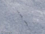
Beyond Longyearbyen, a convoy of snowmobiles carried Street View cameras onto the starkly beautiful glaciers of Spitsbergen. High above the island’s fjords, the views of the surrounding mountains and cliffs are stunning.


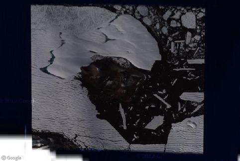
Even in these remote locations the footprint of man can be found, such as this satellite/radar installation.

Sadly, much of the snowmobile imagery sees Svalbard covered in dense Arctic fog, resulting in panoramic imagery such as this:

Even the snowmobiles appear to be disappearing into the mists.

Along the snowmobiles’ journey, the crew reaches another important milestone (well, for the authors of this site, anyway) – the new world’s northernmost Street View imagery at 78.67°N.

At the end of the Street View snowmobile tour is the ghost town of Pyramiden, about 50 km (30 mi) north of Longyearbyen. It’s so remote it doesn’t even register on Google Maps’ ultra-low-res satellite imagery. Founded by Sweden in 1910, the town and its mines were sold to the Soviet Union in 1927, and its residents were Soviet mine workers and their families. As such, Pyramiden looks a lot like most other Soviet-era northern cities with its monolithic apartment dormitories and Siberian-style wooden barracks.


At its peak, Pyramiden was home to 1,000 residents, but the town was abandoned by the mining company Arktikugol in 1998 during the Russian economic crisis. Most of the town was left as is, right down to the footballs in the gymnasium. Pyramiden has spent the last fourteen years frozen (literally) in time as the cold climate has greatly slowed the rate of decay. Visitors are free to enter the town but may not enter the buildings for safety reasons. The Arktikugol logo still stands in the centre of town, and the large civic sport centre still stands in the central square, replete with the world’s northernmost bust of Lenin. Even the children’s playground still languishes in the Arctic snow.


Despite its ghost town status, austere appearance and often inaccessible location, there are plans to redevelop the site as a tourist destination. The Pyramiden Hotel is being reconstructed, and three accommodation containers – yes, containers – can host interested visitors until then. Just remember to bring along your bigbore gun and signal pistol, required for all visitors to this part of Svalbard – as the handful of caretaker workers left at Pyramiden aren’t equipped (nor is it their job) to protect you from menacing polar bears. Seriously.
Learn more about Svalbard by visiting the official tourist board website.
About the author
Kyle is a jack-of-all-trades geographer and archivist in rural British Columbia and was formerly the proprietor of humble geography blog The Basement Geographer. He enjoys a good game of hockey and a good 30-km walk with a frozen beverage in hand.
Unfortunately the Svalbard Global Seed Vault is not covered by the Streetview imagery 🙁
http://en.wikipedia.org/wiki/Svalbard_Global_Seed_Vault
And the aerial shots are not all that exciting View Placemark
And of course the Panserbjørn live there … Kudos to the first to find one on Streetview.
http://images.fok.nl/upload/071203_9155_goldencompass2.JPG
Along with snowmobiles, there are a lot of baby carriages too…