Volcanoes of the Northern Marianas (Volcano Week 7)
Friday, 31st August 2012 by Kyle Kusch
The Mariana Islands are part of a great submerged mountain range that extends 2,519 km (1,565 mi) from Guam to Japan. While the southern Marianas such as Guam and Saipan are known worldwide as tourist destinations, the northernmost islands are completely uninhabited. That’s because the northern islands are actually a long string of active volcanoes fed by the subduction of the Pacific Plate into the Mariana Trench, the deepest location on Earth.
The northernmost of the Marianas is Farallon de Pajaros. The island is called the ‘Lighthouse of the Western Pacific’ due to its frequent eruptions, the last one occurring in 1967. Half a century later, the lava-covered summit of the island remains largely devoid of vegetation, and the caldera on top is quite prominent.


To the south lie the Maug Islands, a group of three islands that mark the partially submerged rim of an ancient volcano. Unlike the active Farallon de Pajaros, no volcanic activity has been known to have take place here in human memory. As a result, the islands are quite lush; even the submerged lava dome 20 m (66 ft) below the surface is covered in coral.

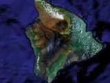
Next after the Maugs is Asuncion, which is unfortunately obscured by clouds in the satellite imagery, followed by Agrihan. Agrihan rises over 4,000 m (13,120 ft) from the ocean floor, and its summit sits 965 m (3,166 ft) above sea level, making it the highest point not just in the Marianas but in all of Micronesia. The caldera alone is 2 km (1.3 mi) wide; it last erupted in 1917, causing the permanent evacuation of the island’s only village. To the northwest, under the trees we can see where the lava flow burst over the caldera rim and ran toward the ocean.


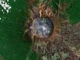
The island of Pagan consists of two volcanoes joined together by a narrow isthmus. The northern volcano, Mount Pagan, emerged less than 1,000 years ago and erupted as recently as 2010. The current imagery dates to 2005, 24 years after the largest recorded eruption in Pagan’s history caused the evacuation of the island’s only two villages – the last time that any of the Mariana Islands north of the capital of Saipan were permanently inhabited. The 1981 lava flows are readily visible by satellite. As well, two small lakes can be seen in the collapsed caldera directly to the west of the summit.

Alamagan is a much smaller island (about one-quarter of the size of Pagan) that has not erupted for approximately 1,000 years. The direction of the medieval pyroclastic flows can still be easily discerned by the lava platforms that stick out of the north and south sides of the island. Even smaller than Alamagan is Guguan. Despite its small size, Gugan actually contain two separate volcanoes. The northern volcano cone emerged in 1883 and produced the black patches of lava still visible today.


The southernmost of the active Marianas volcanoes is the distinctively-shaped Anatahan. This island is most famous for being the home of a group of stranded Japanese World War II soldiers, survivors of ships that had been sunk off the coast, who lived in isolation here until 1951 – refusing to accept that the war had ended six years earlier. The story was dramatised in a 1953 movie by Josef von Sternberg.
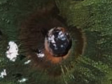
Measuring 10 km (6 mi) long, Anatahan’s first recorded eruption only took place in 2003, creating the massive eastern caldera, seen here still sending gas and smoke into the atmosphere. The western caldera, meanwhile, is partially filled by a lake. Anatahan erupted again in 2007, and this eruption lasted for an entire year. Because of these eruptions, most of island has been stripped almost bare.


Volcanic activity should persist in the Marianas for millennia to come, and odds are that new eruptions will take place on some of these very islands in the near future - changing the shapes of the islands once again (and giving us an excuse to revisit them in a future Volcano Week!)
About the author
Kyle is a jack-of-all-trades geographer and archivist in rural British Columbia and was formerly the proprietor of humble geography blog The Basement Geographer. He enjoys a good game of hockey and a good 30-km walk with a frozen beverage in hand.
All volcanoes deserve our awe but for me Maug Islands were especially interesting, where “interesting” means freakishly unsettling, because of what lies out of sight and submerged 20 metres down. It’s only a tiny consolation that it has been dormant long enough to acquire a verdant top coat above the water line and a coral bed below.