More Shipwrecks
Monday, 18th July 2005 by Alex Turnbull
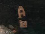
Here's one in Saint Lawrence bay, Quebec...
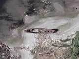
...a beached wreck off the Washington coast...
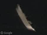
...and finally a super-cool submerged ship in the river Clyde, near Glasgow! (it's great posting Scottish things 😀 )
Thanks to Jacob, Jonny, troy, DDA, Jonathan Hoppe, Patrick, Joel Leo, Mike and Gus (from the comments).
About the author
Alex has decided that his title will be Senior Vice President of Stuff.

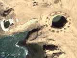
The Washington shipwreck is in Mukilteo on northern Puget Sound. Local fishers use the wreck as a landmark — “there’s good bass north of the shipwreck,” “good catch between ferry and shipwreck”, etc. Google for “mukilteo shipwreck”.
I think the Scots one is the Captayannis
One source I found says that ship is lying on its port side, and that certainly looks like what the one in the pic is doing.
The Mukilteo shipwreck isn’t really off the coast either, its on the Puget Sound.
“Off the coast of Washington” is over here:
View Placemark
Paul,
I think you’re right! From a couple of sources…
Aye you are right, i live just to the right of that picture. See the boat all the time on from the train. Not something id thought to have been classed on a “sightseeing” feature 🙂
Are these abandoned wrecks, or are they just resting? This is Basra waterway, with plenty of traffic (scroll/zoom to see dozens of ships of all sorts), but these two are just lying there on the beach without any port facilities visible…
View Placemark
The Basra waterway look very cool.. I found this one on the East canal : View Placemark And also this one : View Placemark
Triple combo : View Placemark A little on the left : View Placemark There is a lot of wreck ship along the way : View Placemark View Placemark View Placemark
ouh no! my boats! why are you doing this! why!
it was I
Nixx, I was scrolling further down one of the rivers you posted and found this
View Placemark
Looks like a have submerged ship
The Washington SHipwreck is really not a shipwreck. In the book Picnic Point Pathways, they explain how this is from someone who bought old ships and salvged metal and stuff off of them in 1929. They left the frames on the beach there.
Anyone know the name of the Mukilteo wreck? Closest you can get to it without trespassing on the property is at Picnic Point, a ways from Richmond Beach where many old wooden coasters ended their life. It is somewhat intact, with most of the bow gone, but the stern is resting in water
This is also a nice one… Quite a distance from the shore, right in the dessert of Namibia… Imagine you just survived the storm that whased the ship ashore, and now you realize you are in the middle of a desert, miles and miles from the civilized world…
View Placemark (23.996486,14.456903)
The location in Googlemaps
I went out to see the beached ship off of Mukilteo, WA, and I found it is on private property, and is not really accessible. We broke the law by walking the railroad track out to it, but the boat it’s self is on a privately owned beach.
I posted about it (w/ pictures) here: http://adameros.livejournal.com/2585109.html
The beached ship south of Mukilteo, called by the locals as “the shipwreck” is a refrigerator ship that was being towed from Seattle to Everett in 1956. It caught fire underway and was beached to keep it from sinking. The point where the ship was beached was a location that was used in the past as a ship salvage area. A enterprising individual used to tow old ships to the point, where he beached them, stripped them of all salvageable parts and then burned them. The ship is used by local fisherman as a navigation point, and even the Washington State Dept. of Fish and Wildlife lists “the shipwreck” as a landmark to denote the boundary between two Marine Fishing areas.