Glastonbury
Wednesday, 1st July 2009 by RobK
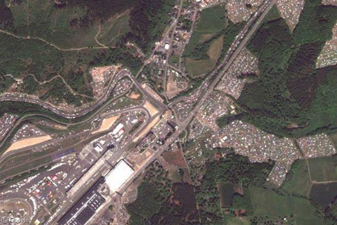
This year's Glastonbury Festival of Contemporary Performing Arts drew 177,000 party people to deepest Somerset, reaffirming Glastonbury's position as the largest greenfield music and performing arts festival in the world.
Some went for the music. Some went for the mud. A few might even have gone for Bruce Springsteen - but no doubt a good (if slightly damp) time was had by all.

Despite its name, the festival is not actually held in Glastonbury, but at Worthy Farm in the village of Pilton, some six miles to the east.1 Google's aerial photos clearly weren't taken at the end of June, as they reveal a remarkably unsullied rural scene - the site is still a working dairy farm. The famous Pyramid Stage is missing, but the foundations (and surrounding dried mud) can clearly be seen, as can the electricity pylons that cross the site.


Of the second stage (known, with a great deal of imagination, as the Other Stage), there is no sign at all - it is situated here, in a peaceful-looking field. (If you squint a bit, perhaps you can just make out a vague dark semicircular area.)

Near the southern edge of the site, you can see the stone circle, a favourite hippy hangout that was built for the festival by a druid, no less.

"Glasto" will be 40 years old next year, but it remains a brief annual blip of madness in the Worthy Farm routine. Once the music is over, the stages dismantled, the last hungover revellers departed and the vast quantities of rubbish cleaned up, Pilton's cows can once again live in peace - until next time. 🙂

It's interesting to compare this map of this year's festival site to the aerial photos, so you can see what happened where.
Thanks to Barry.
-
The distinctive tower-topped hill of Glastonbury Tor, said to be the Avalon of Arthurian legend, can be seen on the skyline from the festival site. ↩︎
About the author
Rob is a subeditor and freelance writer from Hampshire, England, who enjoys travel both real and virtual.
somebody did an overlay showing the festival layout .. damned if I can find it :.
See Boston Big Picture special http://www.boston.com/bigpicture/2009/06/glastonbury_2009.html
In 2008 my tent was right here https://www.googlesightseeing.com/maps?p=&c=&t=h&hl=en&ll=51.152711,-2.593192&z=19 The crap factory over the fence (west) wasn’t too nice. Just as well I spent buggar all time at the tent.
I love your random link to the middle of a field Glenn – if this were any other post that would be a totally weird thing to post.
Except somehow linking to random fields in this thread seems perfectly ok.
Anyway, you’re too late for this year. Now, if you’ve got tickets, Werchter’s on this weekend. Oh dear, and if you haven’t, then you’re too late too.
Something’s happening in the Live Loc – er, I mean Bing Map.
http://www.bing.com/maps/default.aspx?v=2&FORM=LMLTCP&cp=51.158933~-2.580146&style=h&lvl=17&tilt=-90&dir=0&alt=-1000&phx=0&phy=0&phscl=1&encType=1
Good spot, Parabellum. As well as all the cows being moved around, you can clearly see the location of the Other Stage (which is actually a few metres further north than the position I linked to) and the walkways.