Japan after the tsunami
Wednesday, 14th December 2011 by Alex Turnbull
On the 11th March 2011, 70 kilometres off the east coast of Tōhoku, the most powerful earthquake in the country's history struck Japan, triggering a powerful tsunami that swept inland up to 10 km, swamping some areas with waves over 40 metres high. The confirmed number of deaths stands at 15,841, with a further 3,485 people still missing over nine months later.1
The earthquake was recorded as magnitude 9, so powerful that Geophysicists have estimated the main Japanese island of Honshu is now 2.4 metres wider that it was before, and that the Earth itself has shifted slightly on its axis.2
In addition to the unbelievably tragic loss of life, the infrastructure of Japan was severely damaged, several nuclear reactors went into meltdown, and over 125,000 buildings were damaged or completely destroyed.
 Failed reactors at the Fukushima I nuclear power plant
In an effort to assist people during the crisis, Google almost immediately launched updated satellite imagery of northeastern Japan, followed by two more rounds of additional high resolution imagery. These shocking pictures reveal an utterly destroyed landscape, with ships littering the landscape - having in some places come to rest on top of what few buildings remained standing.3
 Ship on a roof, Akahama district, Otsuchi
 In Higashimatsushima, the 45 metre Chōkai Maru was lifted over a pier and left aground
Elsewhere trains can be seen with their carriages piled up, having been completely swept from their tracks.

In July Google announced their intention to capture the scope of the destruction through a new initiative to create an interactive digital archive of the area, using Street View. Since then the Street View cars have driven 44,000 kilometres recording high-resolution images, and the new imagery has just been launched, alongside a new website called "Memories for the future".4
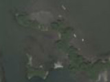
 Minamisanriku, August 2011
The website allows users to switch between before and after views of a wide range of affected locations in northeastern Japan. This unique project allows us to see exactly what kind of impact the tsunami has had on the landscape and its people.
 Minamisanriku, July 2008
 Minamisanriku, August 2011
The transformation is truly shocking. It's unclear from the images exactly how much work has gone into removing debris, but it is clear that whole communities have been totally erased.
 Higashimatsushima, July 2008
 Higashimatsushima, July 2011
As Keir Clarke at Google Maps Mania said:
Let's hope that in a couple of years Google can update the Street View imagery again to show these towns and communities rebuilt and thriving again.
Wikipedia has all the details of the 2011 Tōhoku earthquake and tsunami.
-
Source: Damage Situation and Police Countermeasures associated with 2011 Tohoku district – off the Pacific Ocean Earthquake" (PDF, 6.9KB) ↩︎
-
The tsunami continued on to Antarctica and struck the Sulzberger Ice Shelf, where the Google Earth Blog reports that the force of the wave broke off two massive chunks of ice with a combined area of 125 square kilometres – or more than twice the size of New York's Manhattan Island. ↩︎
-
Here's the same building as seen by Street View in October - the ship has been removed, but the building itself is a ruin. ↩︎
-
In addition to the new imagery and website, Google have added an oft-requested feature - all Street View seen on Google Maps now shows a timestamp in the bottom right hand corner, allowing anyone to see in which month and year a Street View image was taken. ↩︎
About the author
Alex has decided that his title will be Senior Vice President of Stuff.
They had a very good documentary about the Tsunami on Channel 4 (in the UK) not long ago. It’s on Youtube … not sure if the content works outside the Uk though.
Great article. Very powerful images.
let us gain more knowledge tsunami..