“Scientists” Discover Ancient Relic with Google Earth
Thursday, 26th March 2009 by Alex Turnbull
Thanks to the excellent high-quality imagery in Google Earth, some "scientists"1 claim to have discovered a 1,000-year-old forgotten relic of the fishing world.
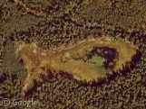
Just off the coast of Wales they spotted this large v-shaped row of rocks beneath the water - which looked like a traditional British fishing weir. This was a fishing method whereby the tide would bring fish through the gaps in the rocks, which would then be blocked by wattle fences when the tide turned to flow out again.

The only problem with fishing in this way was that it was far too effective - this was so well known that the Magna Carta, published in 1215, actually includes the following clause:
(33) All fish-weirs shall be removed from the Thames, the Medway, and throughout the whole of England, except on the sea coast.
So our intrepid "scientists" actually took a trip to Wales to check out in person what they had found, and sure enough, one underwater scuba adventure later, they emerged smugly from the water like some sort of Internet-savvy Indiana Jones'.
How would "scientists" cope these days I wonder, without Google Earth to help them do their research?
Thanks to Frank at the GEarth Blog and Jason Kottke.
-
I have no proof of their credentials. ↩︎
About the author
Alex has decided that his title will be Senior Vice President of Stuff.


How would “bloggers” cope these days I wonder, without Google Earth to help them fill their blogs?
I concur wholeheartedly. There was no need for this overly bitter and snide post about a genuinely interesting find on Google Earth. What would googlesightseeing do without their users doing all the work for them?
OK, point taken guys.
To be honest I was having a go more at the way blogs report this kind of stuff than the people doing genuinely interesting archaeology.
It seems that the only way blogs will write about history or the natural world is if it was “found on Google Earth”. Here at Google Sightseeing, we only write about stuff on Google Earth – so I’m exempting us from this criticism, as we don’t have any choice!
@Steve, yes – we do elicit user suggestions and we are genuinely grateful of them, but these posts don’t write themselves you know!
However, if I wrote an “overly bitter and snide post” then I’ve clearly been spending too much time on Street View. Sorry. Must try harder.
If you follow the chain of links in the blogs, you can see that it was first published in the Telegraph and accredits a “Dr. Ziggy Otto” from an English college. LOL.
http://www.telegraph.co.uk/news/newstopics/howaboutthat/5000835/1000-year-old-fishing-trap-found-on-Google-Earth.html
Well, some of your readers (including me) love your “overly bitter and snide” posts, and your regular posts as well! I’ve been coming to Google Sightseeing for I don’t know how long and I still enjoy every fun and interesting post of yours, so keep up the good work!
I seem to remember that it was not discovered with Google Earth but rather spotted from a plane flying over the location. Google Earth was simply a convinient tool to check up on the find – and presumably plan the scuba diving trip – and maybe even to make a nice KML showing the locations of all the people who read the story on blogs.
Without wishing to blow my own trumpet, a colleague and I found some similar fish traps on the Menai Strait, Anglesey back in 2004. Photos here: http://www.pixaerial.co.uk/php/show_image.php?image=35078
But the crucial question is – are you a scientist or a ‘scientist’?
Agree with first two comments – after looking over this story elsewhere, there seems no basis for your irony. There’s so much crap (and I chose my word carefully) out there about all things trivial to be located on Google Earth, Maps and SV, it seems this could have been a chance to praise people who are basically doing the same as the editors of this page
You don’t need a piece of paper with “Congratulations, you’re a Scientist” on it to be given permission to follow through your curiosity.
Excuse me, but aren’t scientists allowed access to satellite images? Is it somehow cheating to look for achaeological artifacts, impact craters, or the myriad of other features that Google Earth makes freely available (via saltellites images that Google didn’t make possible, BTW)?
Do you know enough archaeology to have interpreted the image as a fishing weir? And where do you get the temerity to actually criticize a scientist for actually traveling to the site in question to examine the evidence to confirm (or not) their interpretation of an image? The effort to examine and confirm a hypothesis is what separates scientific inquiry from useless desktop speculation.
By the way, I found Dr. Ziggy Otto’s email address along with articles about his research and activities.
Dr Ziggy Otto is the senior marine conservation officer with the Countryside Council for Wales.
http://news.bbc.co.uk/2/hi/uk_news/wales/south_west/7874406.stm
Perhaps you’d like to share any LOL thoughts you have with Dr. Otto via [email protected]
Blimey – these ‘scientists’ are a touchy bunch arent they? Ive actually found a picture of the reaction from a ‘scientist’ upon reading this post.
I’m not a scientist…
I’m not a dentist……….
You’re not an investment banker, are you?
Curious, A year ago on the same day this was posted there was another post of someone discovering something using Google earth. https://www.googlesightseeing.com/2008/03/27/google-earth-can-make-you-famous/